
Flood Zone
Know the Risks – Flooding in Goshen
Flood Awareness Public Meeting: March 16, 2023
On March 16, 2023, the City of Goshen held a drop-in public meeting event from 4:30 pm – 6:30 pm at the Schrock Pavilion in Shanklin Park (411 W. Plymouth Avenue) to discuss aspects of Goshen’s Flood Resilience Plan. Attendees had the opportunity to interact with a number of local and regional organizations to ask questions and provide input on water quality and quantity issues in the lower Elkhart River Watershed area. The organizations present included various City of Goshen departments, the Elkhart County Soil and Water Conservation District, the St. Joseph River Basin Commission, and the Elkhart River Restoration Association. Fact Sheet: Flood Awareness Facts and Resources (English and Spanish)
Flood awareness and preparation are important in a community with reoccurring flooding, such as Goshen, as is working with our partners to positively impact the rivers and streams we live with.
To learn more about Goshen’s Flood Resilience Plan a link to the full Plan is provided below. If you have questions or would like to provide input on concerns you have, please contact Aaron Sawatsky-Kingsley at 574-537-3850 or aaronkingsley@goshencity.com.
Future flood awareness public meetings will be held and information will be shared here and through other avenues too.
City of Goshen Flood Resilience Plan
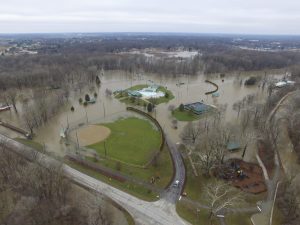
In 2018, the City of Goshen experienced its largest flood event in recorded history. The flood, and the damage it caused, prompted community calls for greater planning to increase Goshen’s resilience against future flood events. The City of Goshen hired Christopher Burke Engineering as a consultant to assist and facilitate the building of a Flood Resilience Plan. The Plan is organized by geographic planning areas based on flood risks and makes recommendations for each. These recommendations range from specific actions undertaken by various City Departments to ordinance updates that limit high-risk development and incentivize future growth outside of flood hazard areas.
The Flood Resilience Plan was presented to the Goshen City Council on July 18, 2022, and was passed unanimously. One council member commented, “This Plan is a playbook to go by and in the future, the actions may be lessened or strengthened to fit the Goshen community.”
Check out the full plan at the link above, provide your thoughts on Goshen’s Flood Resilience Plan by clicking here to fill out a survey, watch the public presentation from March 17, 2022, below, and check out the public presentation slides by clicking here.
Know the Risks Project – Flood Risk Tools and Stories
The “Know the Risks Project” is put together by the Goshen Stormwater Department as part of an effort to increase storm and flood literacy in the Goshen community. The project’s goal is to promote a resilient, adaptive City in the face of a changing climate with greater risks from flooding. Explore the series of “StoryMaps” below:
Understanding Flood Risk in Goshen
Explore flood risks for a location of interest to you. Using data tools from the Federal Emergency Management Agency (FEMA), this story focuses on different methods of assessing flood risks for particular locations across Goshen. The story map provides a guided tour of the available data to provide essential context, but residents can directly access and explore the data here.
Learning from the Past: Historic Flooding in Goshen
Take a look at past flood events in Goshen’s history. This story map came together with a lot of help from community members who took photos of flooding in 2018 and members of the Goshen Historical Society.
Goshen’s USGS River Gauge
Learn how to monitor the height of the river and evaluate risks during a potential flood event using the United States Geological Survey (USGS) river gauge located at the Indiana Avenue Bridge. This story map guides you through how to use the tool and provides context for what different river heights mean for area businesses and homes.
Assessments
Climate Change Vulnerability Assessment for Stormwater
Also in response to flooding in 2018, the Goshen Stormwater Department partnered with the Great Lakes Integrated Sciences and Assessments to undertake a guided vulnerability assessment for stormwater. Climate trends suggest greater risks from flooding in this region and the assessment evaluates a number of locations throughout Goshen for their sensitivity to climatic changes and ability to adapt to the coming changes. The assessment concludes with a vulnerability matrix for selected Goshen areas and makes some recommendations to continue investigating and addressing identified vulnerabilities.
Check out the full plan at the link above (coming soon). Direct questions about the Assessment to Goshen’s Stormwater Department stormwater@goshencity.com
Other Tools
Advanced Hydrologic Prediction Service – See the National Weather Service’s river height forecasts as adverse weather approaches the City. Then use the River Gauge story map above to understand what sections of our City along the Elkhart River might experience flooding at the predicted river crest.
Flood Factor – Use Flood Factor’s address lookup tool to view estimated flood risks for your home or business. This robust tool has additional resources that estimate the cost of damage at different flood heights and offer possible flood proofing solutions to begin protecting yourself against flooding. The tool runs models based on updated methodologies that in some cases go beyond the capabilities of the Federal Emergency Management Agency’s (FEMA) floodplain maps. City staff has found that the tool’s flood predictions in some cases more closely reflect the flooding seen during Goshen’s historic 2018 flood.
Please share your thoughts on the drafted plan by taking the survey below. If you have multiple questions or areas of concern, please submit another survey.
